


Nine beautiful images taken from the ISS and one amazing video
Images from space have been increasingly popular in the news and on social media. Astronauts living on the International Space Station have been posting photos of their mission and earth observations in real time on Twitter and Facebook. The next station crew, Expedition 39-40, preparing to launch to the station on March 25 will be the first to share their flight experiences on Instagram. Check out NASA's Flickr account for all of these images plus many more. 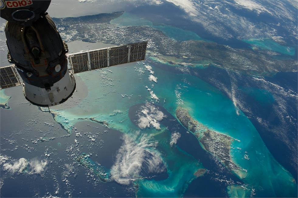
23 Dec. 2013 - The Caribbean country of Cuba appears at the top of this high oblique image, photographed by one of the Expedition 38 crew members. Andros Island, part of the Bahamas, is in the bottom of the frame. Cuba is an archipelago of islands in the northern Caribbean Sea at the confluence with the Gulf of Mexico and the Atlantic Ocean. A Russian Soyuz spacecraft is docked to the station.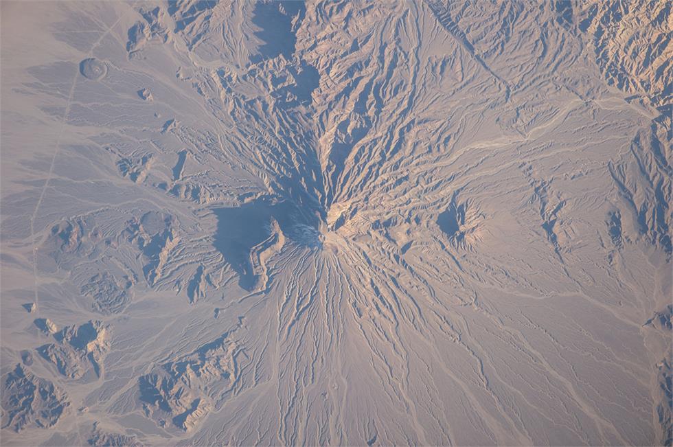
5 Jan. 2014- Bazman volcano in Iran is featured in this image photographed by an Expedition 38 crew member. Bazman volcano is located in a remote southern region within the Bazman Protected Area of Sistan and Baluchestan Provinces. While the volcano has the classic cone shape associated with stratovolcanoes, it is also heavily dissected by channels that extend downwards from the 3,490-meter-above-sea-level summit. This radial drainage pattern - looking similar to the spokes of a bicycle wheel - is readily observed in this photograph.
12 Dec. 2013 - One of the Expedition 38 crew members took this brightly lit night picture featuring much of the Houston metropolitan area. The central business district is in the exact center of the photo, with the Galleria area and uptown being in the lower left with Sugar Land being closer to the lower left corner. The 610 Loop and Beltway 8 encircle the city. The southeast sections extend past Hobby Airport to the NASA/Clear Lake area.
4 Aug. 2013 - A sunset over the Aleutian Islands, with noctiucent clouds, is featured in this image photographed by an Expedition 36 crew member on the International Space Station. The crew member took this panoramic view looking north from the Aleutian Islands when the space station was flying east at "the top of the orbit," the northernmost latitude reached by the orbital complex (51.6 degrees north). If the sun had been higher, the string of Aleutian Islands would have been visible in the foreground.
7 Sept. 2013 - A stationary camera onboard the International Space Station took this picture of the Japanese HTV-4 cargo spacecraft as it entered Earth’s atmosphere on Sept. 7, subsequently burning up. HTV-4 was launched by Japan's Aerospace Exploration Agency (JAXA) on Aug. 4 of this year in order to bring up supplies for the astronauts and cosmonauts onboard the station, and after spending a month docked to the orbital outpost, it was released on Sept. 4.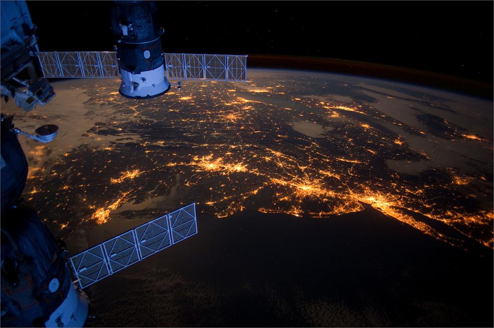
6 Feb. 2012 - One of the Expedition 30 crew members took this nighttime photograph of much of the eastern (Atlantic) coast of the United States. Large metropolitan areas and other easily recognizable sites from the Virginia/Maryland/Washington, D.C. area spanning almost to Rhode Island are visible in the scene. Boston is just out of frame at right. Long Island and the Greater Metropolitan area of New York City are visible in the lower right quadrant. Large cities in Pennsylvania (Philadelphia and Pittsburgh) are near center. Parts of two Russian vehicles parked at the orbital outpost are seen in left foreground.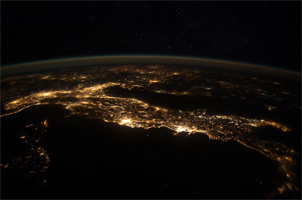
25 Jan. 2012 - This nighttime panorama of much of Europe was photographed by one of the Expedition 30 crew members flying approximately 240 miles above the Tyrrhenian Sea on Jan. 25, 2012. Most of the country of Italy is visible running horizontally across the center of the frame, with the night lights of Rome and Naples being visible to the left and right of center, respectively. Sardinia, and Corsica are in the lower left quadrant of the photo. The Adriatic Sea is on the other side of Italy, and beyond it to the east and north can be seen parts of several other European nations.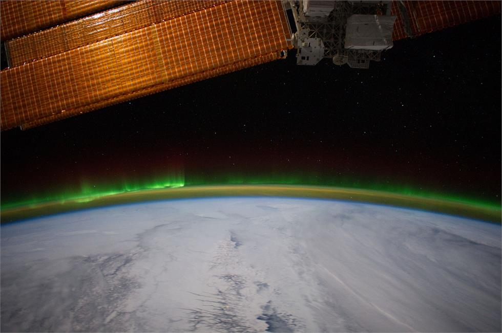
6 Feb. 2012 - Minor activity of Aurora Borealis is easily recognized at left side of Earth's limb in this 24-mm image photographed by one of the Expedition 30 crew members aboard the station from approximately 240 miles above Earth. Clouds obscure what would be any recognizable points on the planet. A section of one of the solar array panels on the orbital outpost is seen in upper left.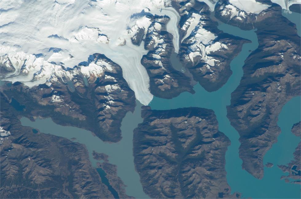
21 Feb. 2012 - Perito Moreno Glacier near Lake Argentino, Argentina is featured in this image photographed by an Expedition 30 crew member on the space station. The largest glacier tongue in this image is known as the Perito Moreno Glacier (center). It descends from the Southern Patagonian Icefield (top) at great altitudes (greater than 2,100 meters, 6,825 feet) in the southern Andes Mountains, down into the water and warmer altitudes of Lake Argentino at approximately 180 meters above sea level. The glacier is 30 kilometers long (image width represents approximately 60 kilometers on the ground). Perito Moreno is one of the largest glaciers in Patagonia, and is perhaps the most famous for the fact that it periodically cuts off the major southern arm (known as Brazo Rico) of Lake Argentino completely from the rest of the lake. This is because the glacier advances right across the lake until it meets the opposite shoreline.
Now check out this amazing compilation of pictures taken from the ISS...